
The Infrared Atmospheric Sounding Interferometer (IASI), flying onboard the MetOp satellite series, is a thermal cross-nadir scanning infrared sounder.
Three instruments provided data:
- Metop-A: launched in October 2006
- Metop-B: launched in September 2012
- Metop-C: launched in October 2018
IASI is a Fourier transform infrared (FTIR) spectrometer which measures the thermal infrared (TIR) spectrum emitted by the Earth and the atmosphere. With a wide swath width of 2 x 1100 km it provides near-global coverage twice a day, with a local overpass time at ~09:30 AM and PM.
It has an instantaneous field of view (FOV) at nadir with a spatial resolution of 50 km x 50 km, composed of 2 x 2 circular pixels, each corresponding to a 12 km diameter footprint on the ground at nadir (Clerbaux et al., 2009), see Figure 1.
IASI has four spectral bands in the spectral range from 645 to 2760 cm-1 (15.5 to 3.63 µm), with an apodized spectral resolution of 0.5 cm-1 and spectral sampling of 0.25 cm-1.
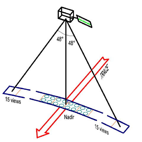
Figure 1 : IASI observing mode. An instantaneous field of view of 4 circular pixels is taken every 50 km, over a swath width of 2x1100 km. Each circular pixel corresponds to a 12 km diameter footprint on the ground at nadir. Taken from Clerbaux et al., 2009.
References
Clerbaux, C., Boynard, A., Clarisse, L., George, M., Hadji-Lazaro, J., Herbin, H., Hurtmans, D., Pommier, M., Razavi, A., Turquety, S., Wespes, C., and Coheur, P. F.: Monitoring of atmospheric composition using the thermal infrared IASI/MetOp sounder, Atmos. Chem. Phys., 2009, 9, 6041-6054.


